
Word: Ayu Arman
Awe and confusion. These two things collided when I and several travellers entered into Misool waters, Raja Ampat, West Papua. We were fascinated by the charming heavenly panorama of limestone islands, bays, straits, karst hills, as well as the clear seawater. It was hard to believe that such a place so full of natural wonders could exist.
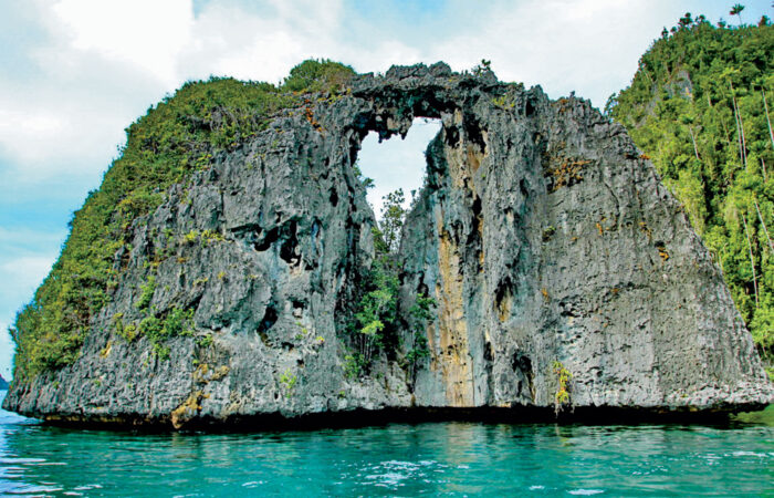
An ancient, majestic and serene kingdom on the sea with a shaded water park emerged in my mind when entering Sunmalelen Island, Sunbayo, Yapap, Dafalen, Lenmakana, Namlol, Balbulol, Puncak Harfat, and other small islands. If not led by trained guides, we would certainly have become lost among the labyrinth-like karst cliffs which stood tall and resembled an array of objects; kingdom gates, reliefs of temples, a king’s crown, a symbol of linga-yoni, a heart, Christmas trees, twin towers, and strongholds.
I realized that Misool with all its charm told me in its silence of its long story of how nature had forged a harmonious relationship between animals and plants; long before humanity ever set foot here. Through geology, the landscape tells the historiography of the earth’s formation which began approximately 4.5 billion years ago.
Geological research tells us the Raja Ampat Islands were formed by the movement of the Pacific plate and the formation of deep waters in the Jurassic period. Around 125 million years ago, or the Early Cretaceous, the Australian continent moved towards the north and formed the archipelagos.
Based on geological estimation, the India-Australia plate moved about 8 cm / year to the northeast and the Pacific plate moved about 10 cm / year to the northwest which later formed the Sorong Fault and thus splitting islands of Batanta, Salawati, Waigeo, Misool, Kofiau and Mansuar. In addition, the movement of the two plates formed straits and the combination of karst landscapes of tropical islands and coral reefs.
Over the hundred millions years, Misool was the best island in its geological outcrop. Its various karst rocks are sedimentary rocks containing macro fossils. The rocks are estimated to have been formed 150 to 240 million years ago when they were uplifted by tectonic processes creating the archipelago of the Misool Island as a reference of biostratigraphy of eastern Indonesia.
In that study, the palaeontologists of the Indonesia Geological Survey Center revealed that Misool Island was formed on the bridge of the northeast edges of the Australian-Gondwana4 since the Mesozoic and were not affected by the formation of Banda arc system.
As mentioned, the rocks in the islands are aged, ranging from Triassic to Cretaceous and containing lots of macro fossils which have experienced tectonic activities such as folding and faulting although such activities had no big impact to the stratigraphy layers. The most complete stratigraphy layers took place in the Mesozoic era, despite the disharmony that took place in the Early Jurassic (Hetangian up to Early Toarsian). The rock sedimentation constantly occurred from the Alenian to Paleogene.
Mesozoic artefacts found in Sumatra, Kalimantan, Sulawesi are not as good as those in Misool which represent a complete Mesozoic biostratigraphy of Indonesia. Biostratigraphy using abundant macro fossil makes Misool a biostratigraphic reference for organisms in Indonesia, even globally. It is not an overstatement that Misool Island’s geo-diversity makes it an important geopark region.
It is an area that has leading geological elements, including archaeological, ecological, and cultural values in it.
This geological park stretches from Balbulol, Yapap, Dafalen, Langkisi, to Harfat. There is also a vast marine lake to check out. Pack your bags and come and discover them one by one.
BALBULOL: MISOOL WATER PARK
After Balbulol Island, Yapap is the second most beautiful island in Southeast Misool. Travelling into this area is like stepping on the great altar of God. This huge primordial pool is adorned with impressive karst formations which look more like chess pieces, flower bulbs, or a row of temples than rocks.

The seawater is crystal clear and shallow bottomed. When the sun shines, diverse corals and white sand are visible from the surface of the sea. Balbulo’s scenery is even more remarkable when viewed from a helicopter or a drone camera. It is as grand as Prambanan, the great Buddhist temple of Central Java, but built on the sea. A little further from the swallow waters, you will see a heart-shaped lagoon like the nature’s love pool. Balbulol island is a natural water park not to be missed.
YAPAP: THE BEST NATURAL POOL IN THE WORLD
After Balbulol Island, this island is the second of the most beautiful island in South East Misool. Travelling into this area is like stepping on the great altar of God. This huge primordial pool is adorned with impressive karst formations which look more like chess pieces of flower bulbs than rocks.
Bulbulol Papua, Indonesia 
Love Stone, Photo: Opan Alting 
Batu Kelamin, Photo: Opan Alting 
Chess Horse Stone, Photo: Opan Alting 
Photo: Opan Alting 
Bird Island, Photo: Opan Alting 
Cliffs Karst, looked like temples – Photo: Opan Alting
Its turquoise seawater is so clear that the sand and coral reefs on its shallow ocean floor are clearly visible from the surface. Swimming and diving is incredibly easy as there are no waves here. The rock pillars around the pool act as guardians and wave-breakers making Yapap island live up to its name as the greatest natural swimming pool in the world.
DAFALEN: ROCK GARDEN
Dafalen island is also located in Southeast Misool. Across the island, you will find a spectacular place with a variety of rock formations that emerge from the surface of the water and invite you to wonder and imagine their shapes and what they resemble.
Love Stones Photo: Opan Alting 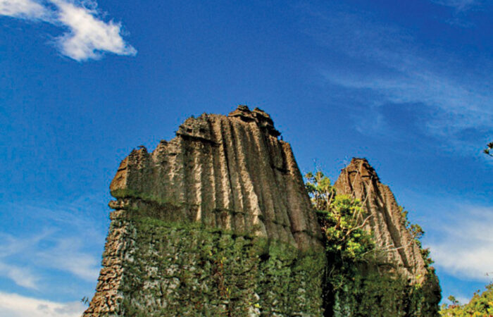
Sail Boat Stone, Photo: Opan Alting 
Cliff Looked Like Temples – Photo: Opan Alting
Rock garden is therefore a fitting name for Dafalen Island. Karst rock cliffs in this park are like giant sculptures created by skilled craftsmen from a distant past. Here you can see cone-shaped cliffs decorated with wild plants, resembling Christmas trees. You may also see the shapes of hearts, towers and strongholds, all with their own story for you to imagine.
STONE TEMPLE IN LANGKISI
Still in South Misool, on Langkisi Island, we found a formation consisting of sandy limestone, carbonate shale, and greenish carbonate mudstone.
Temple Stones Photo: Opan Alting 
Temple Stones Photo: Opan Alting
The process of erosion against the horizontal layering and the vertical plane of its crevices has produced stunning formations that resemble a grand temple in the middle of the sea.
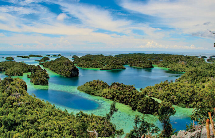
PUNCAK HARFAT: MISOOL CELESTIAL HILL
If North Raja Ampat has the peaks of Wayag and Painemo, Misool Islands has the Harfat Peak. The Harfat Peak is located in the southern part of Misool Island. From here you can see Misool from the top of the coral island.
Peak of Harfat, Photo: Opan Alting 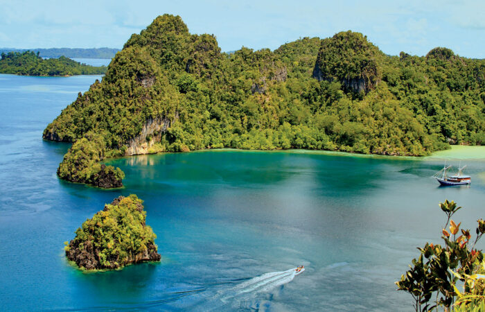
Peak of Harfat, Photo: Opan Alting 
Peak of Harfat, Photo: Reza Alfarobi
The track to the Harfat summit has already been equipped with a ladder and wooden handle, making it easy to be climbed. It only takes about 30 minutes to get to the top of the hill. There are three lookout locations in Puncak Harfat with four different views.
If you look around from the east side of the hill, you will see a lagoon or marine lake with small karst rocks in the background. From the the south of the hill, you will see a small lagoon with a screen of large karst rocks. A cluster of islands is visible from the north side of the hill. The west side of the hill will show you small hills which dot the land.
From these four standpoints you are given a unique perspective of Misool coral island with all the awe it displays.
MARINE LAKE: THE LAGOON OF NIRVANA
Other particularity of Misool is its karst rocks, some of which form a basin of saltwater lake called lagoons or marine lakes.
In Misool waters, there are approximately 200 clear-green saltwater lagoons (lakes) in a variety of shapes adorned with mounds of coral reef whose colours are like a master painting.

Lake of Jellyfish, Photo: Opan Alting 
Lake of Jellyfish, Photo: Opan Alting 
Lake of Love, Photo: Paramiswari 
Lake of Jellyfish, Photo: Opan Alting 
Namloi, Photo: Opan Alting 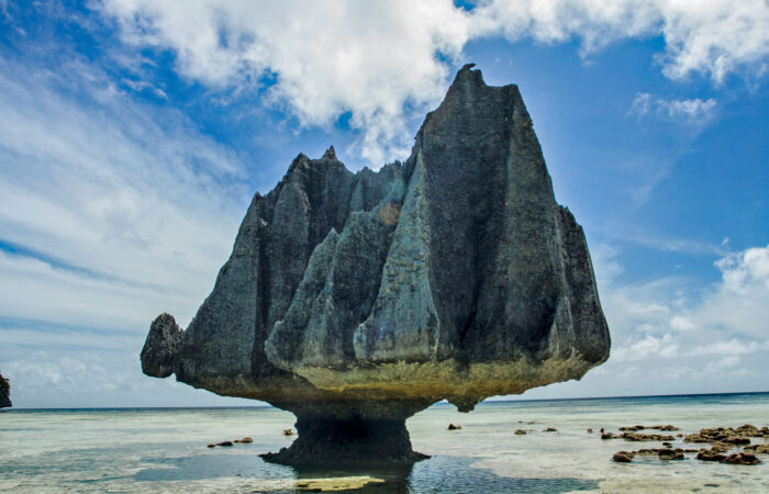
Stones in Namloi, Photo: Opan Alting 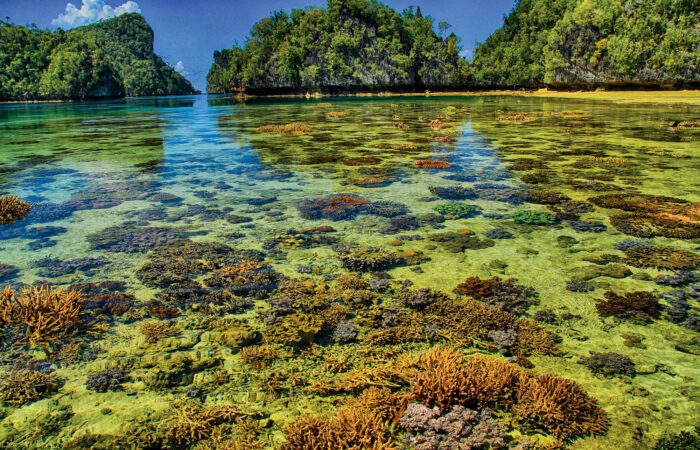
Stones in Namloi, Photo: Opan Alting
Three of them have become jellyfish havens. The coral reefs in these lagoons are also the location where hawksbill and green turtles eat sponges and lay eggs on the sandy beach.
It is said that this marine lake was formed due to rising sea levels after the Glacial period (Ice Age) ended. The deeper the marine lake, the older it is. Several marine lakes are not connected with the surrounding sea, which explains why the water is brackish. Some of them are Lake Namlol, Dafalen Love Lake, and Lake Ubur-ubur at Lenmakana.
NAMLOL LAKE.
This lake is also located in Southeast Misool. It is a marine lake worth visiting. The stretching white sand raises a barrier from the ocean basin. Like a mirror, it has no rippling surface.
What makes this lake interesting is that its rocks resemble ancient creatures and trees. Anyone crossing the island will surely find it difficult not to jump off the boat and swim with the clown fish gliding in between anemones.
DAFALEN LOVE LAKE.
The beauty of this lake competes that with the view of the Harfat summit. From the hill it is easy to see the heart-shaped basin. It is a mystery how the process formed a heart shape with the utmost precision. It is an excellent place for lovers, friends and family to swim together in this symbolic lake of love.

UBUR-UBUR LAKE LENMAKANA
them are accessible. One of those lakes is on Lenmakana island. The lake is filled with jellyfish, especially spotted jellyfish (Mastigias Papua) and one is welcome to swim and dance along with these tentacled sea creatures.
The jellyfish of this lake have a unique migration pattern.
From morning to evening, they move eastward; and from evening to morning, they move westward. The water in Lenmakana Lake is not connected with the surrounding sea since it is held up by the encircling mountain cliffs; thus making its water brackish.
Lake of Love, Photo: Paramiswari Lake of Jellyfish, Photo: Opan Alting
Though currently accessible, you must go through 20 metre of high hills to reach Lenmakana Lake. It is wise to be cautious and to look for and step on strong corals to avoid sliding and falling. From atop of the cliff, thousands of pinkish small dots can be seen by those with a keen eye. They are jellyfish rising to the surface to greet the sun when it is midday.


