
Word: Ayu Arman
THE HIGHEST AND SNOWIEST MOUNTAIN PEAK
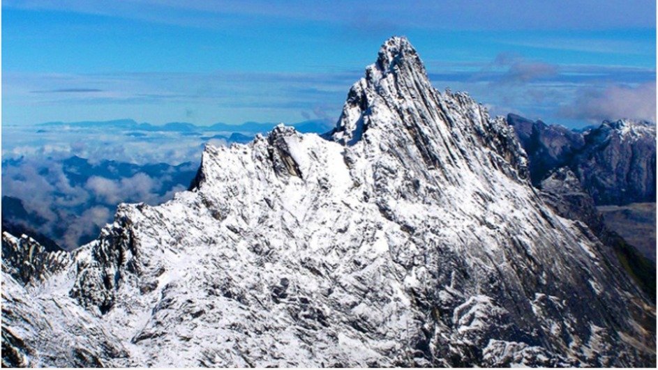
Puncak Jaya or Cartensz with an altitude of 4,884 metres above sea level is the highest mountain peak and the only one with glaciers or tropical ice sheets in Indonesia. That exotica has always provoked the curiosity of nature lovers, researchers, and professional climbers.
Jayawijaya, Indonesia’s highest mountain located in the Central Highlands of Papua, is better known as the Cartensz Pyramid than Mount Nemangkawi Ninggok; a name from the language of the Amungme tribe which means a mountain with a sacred white arrow. Another tribe calls it Ndugu-Ndugu which means a high, snow-covered place where the spirits of ancestors reside.
Mountains, to them, are puja halls, sacred altars, heavenly dańs where the ancestral spirits of the Amungme people reside. The mountain peak is also a symbol of the mother’s kępala, a part of the human body that is highly respected or a symbol of human dignity. All tribes in the Central Highlands region of Papua highly respect and sacredise Mount Nemangkawi Ninggok because it is the final home of their ancestors full of sanctity, wealth, beauty, and magic.
This peak became known as Cartensz after a Dutch sailor, Jan Carstenz. He became the first person to discover the almost entirely snow-covered peak during a voyage across the southern coast of the Arafura Sea in 1623.
He later wrote about the discovery in a journal:
‘On the morning of the 16th we took the height at sunrise. We were at a distance of about 1.5 miles from low ground in 5 or 6 fathoms, muddy bottom. At a distance of about 10 miles by estimate inland, we saw a chain of mountains very high and in many places white with snow, which we considered a very strange sight, considering that we were so close to the equator.’
Jan Carstensz’s discovery was, at first, dismissed as a hoax because in the equatorial region, where the hot sun circulates all year round, there could be no snow. However, over time, world explorers proved Carstensz’s discovery.
Heinrich Harrer, an Austrian climber, along with Russell Kippax, Albertus Huizinga, and Robert Philip Temple, in 1962, managed to prove that the Carstensz is a snowfield.
the existence of snow in the tropical country. They documented their adventure in Seven Years in Tibet.
The snowy mountain was later called Carstensz Peak by world climbers or Puncak Jaya by Indonesians.
Two years later, in March 1964, three TNI members from the Army Commando Regiment (RPKAD), namely Lettu Soedarto, Sugirin, and Fred Athaboe made history by becoming the first local climbers to spread the Red and White on Indonesia’s highest peak in the Cendrawasih Expedition.
UNESCO, in 1999, designated Mount Jayawijaya as the highest mountain in Indonesia and Carstensz Peak was included in the seven summits of the world’s highest mountains that became the world’s climbing target.
UNESCO also designated Cartensz Peak as part of the Lorentz National Natural Park, a world heritage site that must be protected. This is because Cartenz is a tropical region in the world that has equatorial glaciers in the high mountain range in Southeast Asia through a complete spectrum of ecosystems, ranging from coastal ecosystems to the Alps. Within these ecosystems are unique and rare biodiversity in the world and a variety of living cultures. Since then, Carstensz Peak has become the dream of many climbers, both local and foreign.
The snow and ice on some of the peaks of the Jayawijaya Mountains are slowly depleting due to global warming. The Meteorology, Climatology and Geophysics Agency (BMKG) estimates that the ice will disappear by 2025. This estimate is supported by calculations of the shrinking eternal snow area. Originally there were 200 square kilometres of ice-covered area in the Jayawijaya Mountains, but only 2 square kilometres remained by 2022. Although the perennial snow is shrinking every year, climbing to Cartensz Peak remains an unforgettable journey for a climber.
So far, there are two climbing routes to Carstensz Peak. Firstly, the easiest route as recognised by climbers is the route through Freeport’s operational area, from Timika to Tembagapura and then to Carstensz.
This route is ideal because Freeport’s transport can be used up to a certain point before the hike, making it more efficient in terms of time and energy. Hikers are transported by vehicle to Tembagapura.
The hike starts from Tembagapura. However, the procedure to get through the route is not easy. There are many permits that must be obtained, and they must be applied for months in advance.
There is also a route from Timika that is travelled by helicopter and lands directly at the foot of Cartensz Peak. Of course, this shortens the time, but climbers have to dig deeper into their wallets to rent a helicopter.
Second, the Timika-Sugapa route. From Timika, the journey is taken by propeller-driven twin otter aircraft to Sugapa, then to Suanggama by motorbike taxi and continued by trekking through several posts.
Suanggama Basecamp to Jambu Singa Camp (2,181m above sea level) is about eight hours of trekking.
Jambusinga Basecamp to Endasinga Camp (3,222m above sea level) is approximately nine hours of trekking.
Endasinga Basecamp to Ebay Camp (3,580m above sea level) is a seven-hour trek.
Basecamp Ebay to Nasidome Camp (3,726m above sea level) is travelled by trekking also approximately seven hours.
And so on until you meet Lake-Lake Basecamp (4,261m above sea level). From this post, climbers then head to the highest Cartensz Peak (4,884m above sea level).
The trekking path through several posts is certainly more challenging because it is travelled on foot for days through traditional villages, along forests, rivers, rocks, and beautiful and magical cliffs.
At each hiking post, hikers will see and discover thousands of types of plants and animals from the Jurassic era that are still alive today. Also, hikers can witness the panoramic view of lakes with towering rocks with interesting colour patterns, such as Degeli Jagali Lake, Larson Lake, and other lakes around Cartensz Peak.

Around these lakes, you will find kuskus, dingiso, ducks, and various fauna that have yet to be recognised. In fact, climbers can also see the gravity-defying position of a rock at 4,700m above sea level. The rock looks like it is about to fall but remains balanced despite its position on a 900 slope which should make the rock roll downwards.
On the trekking path that passes through several posts to Carstensz Peak, climbers encounter miraculous phenomena and natural beauty that are difficult to describe in words.
From the experience of Cartensz Peak climbers, when standing on the peak, Cartensz looks like a giant boat floating on white clouds like a roll of waves. The sunrise view is also incredible. The mountain rocks sparkle in the sunlight like jewels, giving off multicoloured rays. The cliffs sparkle and the snowfields are vast and hail can come at any time when you are at the top.
For climbers, being at the top of Cartenz is a moment of pure bliss. You can only be silent and hug the amazement in your heart for this God-created landscape from the eastern tip of Indonesia. **